Framework contract between GAF AG and the Bavarian State Ministry of Food, Agriculture, Forestry and Tourism (StMELF) for “Area Monitoring 2024 – First Pillar of the CAP in Bavaria”.
As part of the European Common Agricultural Policy (CAP), GAF AG, an e-GEOS (Telespazio/ASI) company, has been awarded a multi-year framework contract for the automated analysis of satellite data for the monitoring of all agricultural areas in the German federal state of Bavaria. The contract runs for four years and covers the monitoring of numerous crop types as well as the evaluation of compliance with agri-environmental and climate protection measures using optical and radar data from the European Copernicus Sentinel Programme.
As part of an ongoing process of reforms to modernise and simplify the EU’s CAP, since January 2023 the monitoring of subsidy payments has been carried out on the basis of a comprehensive and continuous monitoring concept, using highly innovative technologies and primarily integrating Copernicus Earth observation data.
GAF AG has developed a fully automated, cloud-based system for the technical assessment of subsidy declarations and the monitoring of eligibility requirements using state of the art methods and algorithms. This involves the use of both time series analyses and artificial intelligence (AI) methods.
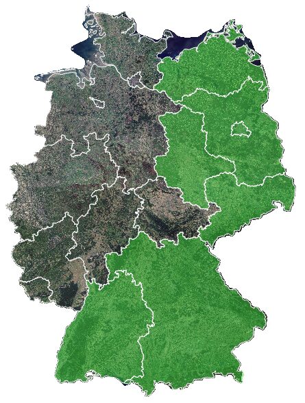
This system has been fully operational for five other German federal states, covering a total area of 199,222 km², since the beginning of 2023. Precise, automated and continuous recording, processing and analysis of Earth observation data in accordance with the newest CAP requirements is ensured. The GAF system provides reliable information for up to 180 different crops and various agricultural activities. It also verifies compliance with certain eligibility conditions and specific compensatory mitigation measures. It therefore constitutes GAF’s next step in providing innovative, hands-on and user-oriented analysis of remote sensing data.

©European Union, contains Copernicus Sentinel-2 Data [2021], processed by the Federal Office for Cartography and Geodesy (BKG)


