The EU-Hydro Upgrade project officially started at the beginning of July. The European Environment Agency (EEA) and the contracted international consortium, consisting of the lead GAF AG, an e-GEOS (Telespazio/ASI) company, and partners e-GEOS, Telespazio Ibérica, DLR and Confluvio, have now therefore launched the first phase of this long-awaited product update.
The Copernicus Land Monitoring Service (CLMS) framework contract for upgrading the pan-European hydrological reference dataset EU-Hydro has now kicked off. The aim with the EU-Hydro suite of products is to provide a key reference suite for hydrological applications across Europe, while also still being a reference dataset for mapping within the Copernicus services. Several new methodological approaches will be tested and implemented for the creation of the EU-Hydro suite of products, with the goal of having them ready for roll-out by mid-2025.
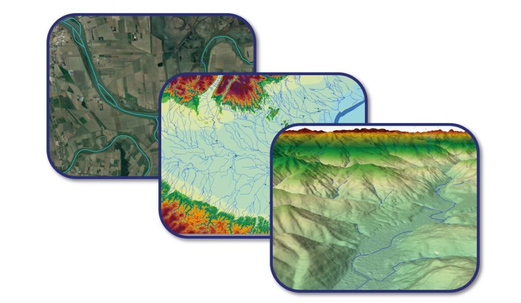
The new EU-Hydro suite of products will be produced for all river basins in Europe. One of the main innovations will be the availability of raster layers — such as a hydrologically conditioned DEM, a flow direction map, and a flow accumulation map — derived from the state-of-the-art CopDEM 10m. Other important additions will be the topologically consistent river network, water bodies and watersheds. The upgrades in EU-Hydro will also include a newly delineated, up-to-date coastline dataset, as well as a specific layer on artificial structures of high relevance for a number of key policy areas, such as nature restoration and climate adaptation. These will include barriers and protective structures, all topologically consistent with the river network.
As a reference dataset in the CLMS portfolio, EU-Hydro provides detailed insights into water resources. It combines data from various sources — including the Copernicus Digital Elevation Model (COP-DEM) and national hydrographic datasets from Member States, as well as space-based imagery — to deliver information on the physical characteristics and geographical distribution of Europe’s water bodies.
Besides its use as a reference dataset for many CLMS thematic products, the updated version of EU-Hydro will support a wide range of applications within the hydrological domain, such as water resource assessments, water quality evaluations, environmental protection strategies, hydrological risk assessments and climate changes studies. The need for it in terms of supporting society-related risk assessments is further emphasised by the rising frequency of natural disasters, such as droughts and floods. With its high-quality, free and openly accessible data, EU-Hydro will help address these challenges and the urgent requirement for enhanced water resilience in Europe — as highlighted in this year’s edition of the EU Green Week.
The work in the project will be carried out by an international consortium operating under the leadership of GAF and including Telespazio Ibérica, e-GEOS, DLR and Confluvio.
© European Union, Copernicus Land Monitoring Service 2024, European Environment Agency (EEA), Microsoft Bing Maps